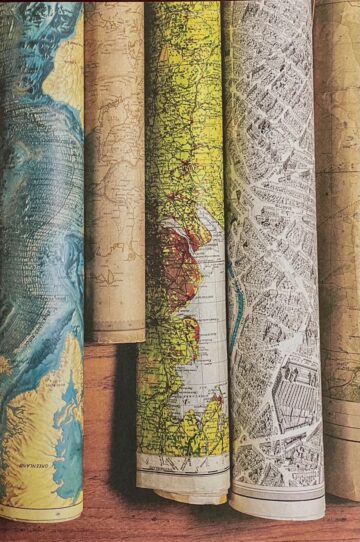
It is a scene that feels straight out of fiction, the jumping-off point for a fable. In the bowels of a building at a London university, a curious professor opens a turquoise door that reads “Map Room.” Inside lies a forgotten space—largely undisturbed for decades—filled with cabinets bearing more than 400 drawers. They hold thousands of maps and atlases of everything from cave networks to mountain ranges to capital flows to the surface of the moon. Some of the documents are hundreds of years old and threaten to break apart in the hand; many are elegantly rendered with the tools of a bygone age, full of vibrant colors that have not been exposed to daylight for generations. The room is like a portal to the past, waiting to be seen.
The Library of Lost Maps begins in this way, with a suitably romantic discovery that evokes the musty, analog nature of the map room’s treasures. When the cartographer James Cheshire stumbled into the room in University College London several years ago, he encountered less a resource for mapping the modern globe than “an epitaph of a world we once knew.” Digital maps have long since superseded the types hung on walls; the phone in your hand can instantly pull up images of any point on land. Yet the printed documents still have value; they are pieces of history, time capsules worthy of rescue and celebration. Mr. Cheshire set out to explore the map room’s contents and has reproduced his findings in a beautifully illustrated book designed by Anna Green.
One of the early documents that Mr. Cheshire found is an atlas produced by the Society for the Diffusion of Useful Knowledge between 1829 and 1844. The London-based organization—whose name sounds like a gathering of silly eminences from Susanna Clarke’s novel Jonathan Strange & Mr. Norrell (2004)—distributed scientific resources at a low cost for the betterment of the public. The atlas project proceeded in fits and starts, with meeting minutes from 1831 recording, “the Committee was summoned for this day but Capt. Beaufort alone attended.” What followed was an interminable undertaking to create maps of individual countries, to be mailed to subscribers and later bound together as an atlas. Customers howled at the delays and the random order in which the maps appeared. Yet the ensuing volume—which cited such landmarks in Africa as “Herds of Gazelles” and “Loose Sand”—helped spread geographic knowledge and target social problems such as urban poverty.
Not all maps aim to reproduce borders, mountains and seas. In the mid-19th century, a trend emerged to create topic-based maps depicting population, education, climate and history (including conquests). One extraordinary map from 1834 shown in the book compares the lengths of the world’s rivers in lines that branch outward from a central compass rose. It is disorienting in precisely the way maps are not meant to be, with the Great Lakes appearing next to Venezuela, yet it also helps one see the world anew. Likewise, a pair of maps focused on the north and south poles give the Earth a sea-based orientation, centering water with land off to the periphery. Heinrich Berghaus conceived of the first major collection of topic-based maps, on such subjects as disease and the distribution of animals, called the Physical Atlas. The book appeared in three volumes beginning in 1838. Mr. Cheshire was astonished to find a first edition in UCL’s map room.
Maps fused politics and geography as never before during the Paris Peace Conference that followed World War I. It was the closest that modern statesmen have come to having a blank slate to fill in with nations. Poland, for instance, lacked the types of natural landforms (mountain ranges, rivers) that could easily suggest political boundaries on a map. Eugeniusz Romer, a Polish cartographer, therefore cleverly mapped central Europe by emphasizing districts and their chief towns, suggesting, a Polish “population terrain” distinct from neighboring countries. The map was used at the Paris conference to help shape the borders of modern Poland.
Another type of map carried grave implications for the 20th century by breaking down nations into racial and ethnic categories. While browsing a map of Madrid from 1940, Mr. Cheshire spotted a stamp in the top-left corner identifying its provenance: a black swastika. The Nazis had gotten their hands on a Spanish guidebook published in 1929 and reproduced the map for military use. An atlas of eastern Austria divides the population to show Catholics in red, Protestants in blue, Jews in yellow and Roma in black. The text of the atlas describes the Roma as a people that had “overmultiplied” and should disappear from the region. The Nazis also used maps as propaganda, “by suggesting, for example, the encirclement of Germany and conveying its vulnerability to attack from neighboring states.” One of the leading German geographers of the era, Karl Haushofer, was a father figure to Rudolf Hess and Adolf Hitler.
Some of the most striking images in The Library of Lost Maps show what is underneath the sea. Mr. Cheshire profiles Bruce Heezen and Marie Tharp, who dedicated their professional lives to mapping the entirety of the ocean floor in partnership with National Geographic magazine and, later, the U.S. Office of Naval Research. The resulting 1978 masterpiece—sublimely detailed and marvelously strange in its presentation of unseen ridges, troughs and endless plains—reflected the newly established theories of plate tectonics and continental drift. After coming across Heezen and Tharp’s work in the map room’s “oceans” drawer, Mr. Cheshire traveled to the Library of Congress in Washington, D.C., to see the original, waiting in delighted suspense for the hand-painted map to be brought up from the vaults. He writes that he “spent three joyful hours” pouring over its extraordinary contours and terrain.
The experience sums up the difference between paper maps and the digital apps that have replaced them. As is so often the case, analog objects yield absorption and study, while their digital counterparts receive our fleeting attention—consulted quickly and then forgotten. It is hard to imagine spending three hours lost on an app in wonder and delight; instead, we consult digital maps for directions to the restaurant and then put them away. Thankfully, “The Library of Lost Maps” collects and presents some of the great maps of the past for leisurely perusal. Readers needn’t travel down dusty corridors or through mysterious doors to find them. Although that does sound like fun.